Friday, April 26, 2013

Nordstrand

Nordstrand, an island in the North Sea of the Frisian coast
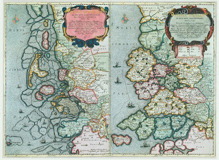
Image from Wikipedia

1634


Nordstrand, the home of Volkje Jurriaens, was once a much larger island encompassing many villages and thousands of people. In 1634 a great flood (Burchardi) swept the island destroying many of the villages and killing thousands.

Nordstrand sits off the western coast of the Jutland peninsula, near the port of Husum. Historically, it and the other islands and marshes in the area were called Uthlande (Utlande). They were identified as such because the islands and marches were inhabited by Frisians, a distinct ethnic group.

The island and city are located in the province of Schleswig, which can be imagined as that slice of the southern Jutland peninsula that separates Denmark from Germany. Schleswig has always been a melting pot of Danes, Germans, and Frisians. Today, Schleswig is divided between Germany and Denmark, Germany possessing both Nordstrand and Husum.

So, the question arises, "Who do the inhabitants of Nordstrand come from - Vikings, Danes, Saxons, Jutes, Frisian or Dutch?"

Roman History


The Eider River is the longest river in the northern German state of Schleswig-Holstein. Roman history places the Jute tribe to the north of the Eider River, Angles to the south, with Saxons in territory adjoining the Angles.

Middle Ages


During the Middle Ages, the population was a mixture of Danes, Saxons, and Northern Frisians. The Frisians inhabited the coastal areas. From the 8th to 13th centuries, Vikings in their longboats ranged throughout Europe. King Canute of Denmark even launched a successful invasion of England in 1016.

Schleswig


Schleswig is both a city and province in Germany. The Duchy of Schleswig appears as a political entity sometime around the 12th century.

detail Danorum Marca, 1588 by Mark Jorden
The detail of the map of Jutland highlights the island of Nordstrand, identified as De Strant and neighboring Husum (Husem). For reference, the Eider River flows to the south of Nordstrand and Husum. The river is the dividing line between Schleswig and Holstein, a province often associated with Schleswig.

The map of 1588 identifies at least 18 small villages on the island. Johannes Blaeu's later map of 1688 reveals the damage to the island, the flood destroying all but four of the villages, leaving only the villages of Pilworm (Pellwurm), Gpell, Gaickebull and Odenbull.

The question remains as to whether Jan Franz Van Husum and Volkje Jurriaens were Dutch or Frisian. That question probably can't be answered. But what is known is that the Frisian dialect was spoken throughout Nordstrand before the flood. Afterwards, the dialect was kept intact only on the small remaining island of Pellwurm where industrious farmers quickly rebuilt the dikes after the flood.


Detail, Johannes Blaeu's 1662 map of the Duchy of Schleswig


Detail from Johannes Blaeu's,  Ducatus Sleswicum sive Iutia Australis, 1662. Original image, Wikipedia.

Now look at a modern view of Nordstrand from Google maps.

Nordstrand, Google Maps 2013

Volkje and Annetje Jurriaens are both identified in later documents as coming from Nordstrand. What they or their parents did is lost to history, but reference is made to the fact that their parents died in the flood of 1634. In 1639, Volkje married Jan Franz Van Husum. Je is identified as coming from the neighboring town of Husum, but again there is little detail, other than a reference to his occupation as seafaring man in his marriage certificate to Volkje. A month after thier marriage, they sailed across the Atlantic in the ship Den Harinck, arriving in the port of New Amsterdam. Annetje also married and emigrated to the New Netherlands.

While the article is being written, you can visit the island in photos.

[Note about Spellings. The spelling of names vary for many reasons. Language differences account for many of the differences. Maps may contain Latin words, a marriage license might be in Dutch, and German, and Flemish might also enter into the equation. Then there is the lack of a uniform code of spelling that existed at the time. The first English dictionary was drafted in 1604, and Samuel Johnson's more famous Dictionary was not published until 1755. The first known Dutch dictionary was published by Cornelius Kiliaan in 1599.]

Wednesday, April 24, 2013

Husum

It is from the town of Husum that the family names Van Huss, Vanhooser, Van Hoesen come.

Jan Franz Van Husum is the first known Van Huss to take the name. He was born in 1608, survived a great flood in 1634, married Volkje Jurriaens von Nordstrand in 1639, and set sail for America the same year. The couple would settle at Fort Orange, on the Hudson River, part of the Dutch colony of New Netherlands.

Husum, from Wikipedia

Today, Husum (North Frisian: Hüsem) is a port city, located in Nordfriesland in Schleswig-Holstein, Germany. Located along the North Frisian coast, the town, through the centuries has belonged to different nations and principalities, including Denmark, Germany, Schleswig, and Schleswig-Holstein. The peninsula on which Husum sits is called Jutland. In 1608, the city was part of the Duchy of Holstein.

Detail of Blaeu's map of the Duchy of Holstein, 1645 (Wikipedia)
Origin of the name "Husum"

The name of the town Husum is first mentioned in history in 1252, for it was at Husumbro (Husum bro, literally, the "bridge between houses") that King Abel of Denmark met his death on the bridge in Husum trying to subdue a revolt by Frisian peasants who refused to pay their taxes. While the geography of the region has changed over the centuries, the bridge would likely have been over the Husumer Au, an inlet which separates the two halves of Husum.

The name "Husum" itself is made up of "Hus" and "um". Hus means "house," (German and Danish; in Dutch "huis", but pronounced the same). The most likely explanation for the addition of "um" is that it is a Latin ending denoting a singular grammatical number. The prefix "van" means "from." Thus, we have "Jan Franz from the city of Husum".

The larger region around the city of Husum is known as Eiderstedt, and the settlement of Husum ended the trade route along the western coast of the Jutland peninsula where cattle was driven south to Dutch and German markets. The name Eiderstedt, "city of the eider duck" suggests that ducks and geese were also raised in the area for southern markets.

Husum Seaport

Detail of Carta Marina, Husum highlighted


Ortelius map of 1572, Husum highlighted
[Both maps from Wikipedia. Carta Marina, created by Olaus Magnus, 16th century, is the earliest map of Denmark and the Jutland peninsula. Abraham Ortelius, who is Flemish, spells the name of the town "Huysen," Johannes Janssonius, a Dutch cartographer uses a similar spelling. Willem Blaeu, another Dutch cartographer, spells the city "Hussum".]

The two maps above reveal that Husum was not always a seaport. That it became one is an accident of nature. In 1362, a flood of biblical proportions, called the Big Man-Drowning (Burchardi Flood or Grote Mandrenke) devastated the area and brought the sea closer to the town of Husum. It also created the island of Nordstrand where Jan's wife Volkje hailed from. Another flood in the year 1634 would again sweep over Husum and Nordstrand affecting the lives of both Jan and Volkje.

Van Hoesen

Van Hoesen, "from the city of Hoesen" is another variation in the spelling of the family name. It is but a slight change in the spelling of "Huysen" found in Ortelius' map. Once in New Netherlands, Jan Franz Van Husum changed the spelling of his name to Van Hoesen. Interestingly, his eldest son was baptized in 1640 in the Dutch Reformed Church as "Van Huysen," using Ortelius' spelling. Early Records of the City and County of Albany: Deeds. 1678-1704.


Sunday, April 14, 2013

Marriage Certificate

The journey


On the 15th of May, 1639, my wife and I, newly-married in Amsterdam's Nieuwe Kerk, walked up the gangplank on the ship Den Harinck, prepared to set sail from Amsterdam for America, from the Old World to the New. With us we carried our worldly possessions, a bible, a spare shirt and pants for me, a dress and chemise for Volkjie, and the little bit of food the captain allowed us, otherwise our provisions were to be provided for by the ship's steward on the journey that was expected to take two months.

One does not wish to remember the journey. I was a seagoing man who had sailed the North Atlantic for its fish, but my wife was unfamiliar with the waves, the storms, the motion of the ship that left her sick for most of the journey. Thus, it was relief that we arrived in New Amsterdam early in July. Compared to Old Amsterdam with its population of 200,000, its busy port, many beautiful homes, tall churches, and bustling markets, this New Amsterdam was disappointing. This place of perhaps a 100 souls was founded no more than 15 years earlier. All that it had to show for itself were a few cabins constructed of logs, and a wharf where beaver pelts were gathered, having been traded with the local Algonquian Indians in exchange for paltry items of not much value. The city, if I may call it that, was at the far end of New Netherlands Bay where the Hudson River emptied into the Atlantic.

Thank God we did not intend to stay here with the miserable souls who were left to contend with the rain, the mud, general gloom that was so unlike the city of Amsterdam we had left.  Our destination was up the Hudson River to Ft. Orange, an outpost of the Dutch West Indies Company, where the patroon, Kiliaen van Rensselaer established his colony and would give us land in exchange for work..

The future


Jan and Volkje settled down, went to work, raised a family, and prospered. They are the progenitors of the tens of thousands of individuals in the Unites States with the surnames Van Husum, Van Hoesen, Van Huss, and with other minor variations.

Dam Platz Amsterdam 1659, by Jacob van der Ulft, Musee Conde, Chantilly


The marriage of Jan and Volkje


Jan and Volkje married a month before sailing for America. The marriage took place in Amsterdam's Nieuwe Kerk on the Dam Platz.*

Some say they were Dutch, others say Frisian, an ancient tribe of people who lived along the coast and were first mentioned by the Romans. What we do know is that Jan came from Husum and Volkje from the island of Nordstrand.

Both city and island were part of ancient North Frisia.

Korte Tuinstraat


Korte Tuinstraat,** where they lived in Amsterdam, can still be located on Google Maps. It is a short walk from Tuinstraat to the Dam Platz and the New Church. It is also a short walk to the house of Rembrandt van Rijn, Holland's most famous painter of the same period.

 [Note. This is a draft article that concerns the marriage of Jan and Volkje Van Husum. The original working image of the marriage certificate comes from jeanhounshellpeppers.com. I have included her translation below with some minor changes.]

Marriage Certificate of Jan Van Husum and Volkje Nordstrand

The image is not original. It is a digital recreation of the marriage certificate of Jan Van Husum and Volkje Nordstrand.

                                                          The 30th of April 1639

Present for signing "Jan Franz van Housum, varensgezel", seafaring man, age 30 years, living in "Cortetuijnstraat," having no parents but assisted by his cousin Anna Jans, of the same (street) and Volckje Juriaens "dr von" (from) Noortstrant, age about 21 years,  same address, having no parents, but assisted by Isaack Pietersen, acquaintence.
Requesting their three Sundays' proclamation, in order to have the before mentioned marriage  solemnized and consummated, in so far as there are no lawful objections, and if fully that they are free persons, not related by blood, whereby a Christian marriage could be prevented, such grounds do not exist, their banns are allowed.

* The Nieuwe Kerk (New Church) was destroyed by fire in 1645 and rebuilt in its present day Gothic style. The New Church was new, even in 1639, at the time of Jan and Volkje's marriage, because the Oude Kirk (Old Church) in Amsterdam had become too small for the growing congregation. Today, the former church is operated as a museum.

**Tuinstraat translates as "Garden Street." It is located in the Jordaan District just off of central Amsterdam. Corte is not Dutch, it may be Spanish, translating as "court."  One looking for the address where Jan and Volkje lived would be advised to look for a courtyard on Tuinstraat, assuming that a 17th century courtyard still exists.

Sunday, March 17, 2013

The Dutch in America

Jan Franz Van Husum arrived in America in July of 1639, settling down in the newly established colony of Fort Orange on the Hudson River with his wife Volkje. They raised a family of nine children. Jan engaged in the beaver trade with the Mohawk Indians, bought land, and prospered. Jan died at the age of 61 in 1669. Volkje lived on until 1703.

New Netherlands, titled New Belgi, original map 1665 Wikipedia

See another map of New Netherlands, 1665.

During this time the Dutch colony of New Netherlands came and went. The earliest Dutch settlement was in 1613. Recognizing a lucrative fur trade with the Indians, the Dutch chartered the Dutch West Indies Company to establish colonies and bring over settlers.

In 1617 the Dutch established Fort Orange at the confluence of the Hudson and Mohawk rivers where the city of Albany is now found. By 1629, Kiliaen van Rensselaer, a charter member of the Dutch West Indies Company, established Rensselaerswyck, surrounding Fort Orange. Van Rensselaer chartered several ships to bring in settlers for the new colony. This likely included the ship Den Harinck, which arrived in July of 1639 carrying Jan and Volkje.

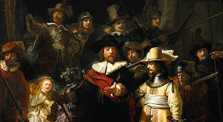
detail, Rembrandt's The Night Watch, 1642

The colony prospered. During the 1640s, Beverwijck, (beaver village) a settlement of fur traders north of the fort, was established. Beaver pelts were bought from the Mohawk Indians and shipped back to Holland where they were made into hats worn by the rich. (See the gentleman in the center of Rembrandt's painting The Night Watch). As I noted, Jan and Volkje prospered. Jan bought for the price of 500 guilders, about 70 beaver, his own land in June of 1662 from the Indians, calling it Claverack, (field of clovers). Van Rensselaer, who was not a man to be trifled with, sued Jan over the question of title.

Call it a stroke of luck or the fortunes of history.

In 1664 King Charles II of England turned his eye to the Dutch colony in America. James, Duke of York and brother to King Charles II, chartered four English frigates. They sailed into the port of New Amsterdam and achieved a surrender of the Dutch colonies without firing a shot. The Dutch colonies officially became English three years later with the Treaty of Breda.

This was fortunate for the Van Husum claim, for the new English courts sided with Jan and his heirs. And the first English colonial Governor Richard Nicolls granted the land patent at the colonial capital of Albany on May 14, 1667.

Notes.

1. Jan and Volkje were a part of a large group of emigrants from Schleswig. This emigration took place after the terrible flood of 1634 and was also a result of the religious wars that shook northern Europe. Schleswig-Holstein Immigrants in New Amsterdam/New York,1636 - 1667.

Jan is identified "Hans Fransen", number 24 on the list of immigrants.

2. Beaver pelts trading took place from May to November, a time called the Handelstijd (trading time). The Mowhawk Indians would bring their pelts to town and the townspeople would all engage in "earning a pelt". At its height, the Handelstijd took in 50,000 beaver pelts. these pelts were then shipped to European markets. See Rituals of the Handelstijd at Beverwijck, by Donna Merwick. Beaver pelts fluctuated in price between 6 and 8 guilders a pelt. See Money Substitutes.

3. For more information about early Dutch history, read A Tour of New Netherlands.

Friday, December 21, 2012

Stille Nacht

I often remind myself that though we are different in many ways, we are one family sharing a belief in a greater goodness.

Johannes Van Husum and his wife Volkie, spoke either Dutch or German. They came from the Cimbrian Peninsula, now called Jutland, an area inhabited by the ancient tribes of Cimbri and Jutes. Johannes lived in the coastal town of Husum. It is for this reason, that the name Van Huss and Van Hoesen and all the other variations owes its existance. Volkie Van Nordstrand grew up on the adjacent island of Nordstrand.

Tragedies are both devastating and uplifting. They define the human spirit, for no matter how deep and difficult the loss, it is the human spirit to rise above difficulties and persevere. So it was on the night of October 11, 1634, when a devastating flood swept over the island of Nordstrand and much of the coast, killing thousands and rendering many thousands more homeless as winter approached.

The story of  the flood and its aftermath is best told by Cor Snabel.

But what Cor Snabel doesn't tell us is that a young Volkie and her sister survived the storm, even though they lost their parents. Volkie and Jan would meet, move to Amsterdam. They fell in love, married and set sail to the New World two years later.

The German language and its Dutch variation lingered on in America for well over two centuries. And it is known that many of the descendants of Jan and Volkie spoke German in their homes. This was true at least until the lives of  Valentine Van Huss and his son Mathias, who lived in Tennessee. This became known when a modern descendent discovered hidden in a barn two religious books written in German.

It is to Valentine and Mathias, to Jan and Volkie and to all those who have suffered tragedy in life that I dedicated this beautiful rendition of Silent Night in the original German.

May you know the peace of God's mercy.


Wednesday, November 21, 2012

Traveling in a Covered Wagon

Traveling in a Covered Wagon.

Before the train, before the highways, I have often wondered what traveling in a covered wagon must have been like. It was an experience shared by thousands of settlers who spread out across America.

The Conestoga wagon, the most well-known of the covered wagons, is first mentioned in print in 1717 in a letter to William Penn. Its name comes from the Conestoga River of Lancaster County, Pennsylvania, the destination for many traders from Philadelphia and the destination for the Van Hooser clan after leaving New York. A settler's journey west across the prairie was usually made in a  Prairie Schooner, a half-sized version of the Conestoga, less broad, flatter than the Conestoga, and thus easier to make the long tortuous route. History, Conestoga wagon.

For a moment we can imagine that on several occasions, the Van Huss clan packed up their children and goods and made the slow journey by covered wagon from one home to a new one on the frontier. Perhaps, the journey was made through the Allegheny Mountains from New York to Pennsylvania.  In 1787, American patriot and physician, Dr. Benjamin Rush, described its importance as a tool on the family farm: "A large strong waggon covered with linen cloth is an essential part of the furniture of a German farm. It is pulled by four or five large horses of a particular breed, and will carry 2000 to 3000 pounds." Certainly then, the Van Huss/VanHooser clan made their journey in a Conestoga wagon from Pennsylvania to Virginia and North Carolina, and then again across the Appalachian Mountains to Eastern Tennessee. And then in either a Conestoga or in a Prairie Schooner, from there they traveled across the wide Mississippi River and across Missouri, until finally, my wife family reached the broad plains of Kansas.

Colonial Sense has an excellent article on the Conestoga wagon.

The only reference to travel in a covered wagon that I have found to date is the mention that in the 1870's Josie Brewer, my wife's great grandmother, left Allentown, Missouri to homestead in Butler County, Kansas. Her trip and her remembrances was probably not unlike the following story.

What follows is a remembrance by Judge Harvey Harrison in 1889 of his travels in 1829 from Alabama to Warrensburg, Johnson County, Missouri. Harvey Harrison was born in 1806 in Blount County, East Tennessee.

Conestoga Wagon. painting by Newbold Trotter, Pennsylvania Historical Museum


When I was six months old, my father moved to Alabama. I was married on the 12th day of March 1829. This year, father and our family, myself and my wife started for Missouri. My father had an old-fashioned Virginia wagon hauled by six horses and had it full of his goods. He also had a one-horse buggy and besides this a two wheel gig, stout and strong. ... We reached the Mississippi River at St. Louis and crossed it there. I would say that it was a town then about as large as Warrensburg is today.
 In 1831, [...we} settled two and a half or three miles west of what is now Fayetteville, Missouri [south and east of Warrensburg].  We unloaded on the 22nd of March 1831. In two days we had a shelter or camp rigged up and in two weeks each family had a cabin of poles or logs with ground floor and clap-board roof, very comfortable. When we arrived there was but one cabin south of Blackwater creek and that was a cabin ...
 The country was most delightful. It was one vast expanse of undulating prairie and in mid-summer covered in tall waving grass interspersed here and there with strips or belts of timber along course of little streams. the choicest variety of game abounded. Absolutely beautiful.
Every autumn when the prairie grasses had withered, usually in November , the prairies were burned. Probably these fires were started by the Indians for the purpose of driving game ... The prairies would then become a vast sea of flame and woe to the settler who had not taken precautions to guard against them. While these fires raged we had about four or six weeks what was known as Indian Summer and for weeks the fire was so dense we could not see the sun. In the spring the ground would be free of grass and the wild flowers would spring up in an endless variety and profusion. ... The prairies would be one vast flower garden ... .
 History of Johnson County, Missouri pages 89 and 90.

The covered wagon  had a life-span of little more than a hundred years, covering the later part of the 18th century and ending before the beginning of the 19th century. Before the highways and trains, it was the means by which settlers moved their families and goods west. There are few surviving examples of the covered wagon in existence today. Certainly, they had features in common, but since the early wagons were built by individuals, they varied by geography and by builder.

Mark Gardner has written a good description of Wagons on the Santa Fe Trail, 1822 - 1880, which is a good starting place in understanding what the covered wagon was.

The Conestoga or Pennsylvania wagons are covered with three or four cotton sheets drawn close at each end so as to exclude moisture, and these are supported by high hoops, and. as those at the ends of the wagon are very much higher than the middle, it has a very singular appearance. The height to the tops of these hoops are from eighteen to twenty feet. They are drawn by ten mules or six yoke of oxen, and contain about forty hundred weight of goods.
See, Frank S. Edwards, Missouri Volunteer in the Army of the West, 1846, of Wagons on the Santa Fe Trail, pages 6 and 7.


Thursday, October 4, 2012

Settling Kansas 1875

The period from 1860 - 1870 is a little cloudy. In 1860, Valentine Worley Van Huss and his wife Lucinda (nee Carter) were living in eastern Tennessee near Elizabethton.

[The middle name "Worley" comes from Catherine Worley, born 1769 in Rowan County, North Carolina, died 1796, Wythe County, Virginia. She married Valentine Felty VanHuss in Wythe Co. Va.. He was born February 14, 1768 in Rowan Co. North Carolina, and died March 1, 1858 in Johnson County, Tennessee. They had several children, including Matthias, father of Valentine Worley VanHuss.]

Valentine Worley and Lucinda had at least five sons, including, James M., Daniel S. Robert E., Isaac, and John Finley.

By 1870, Valentine and his wife  Lucinda were to be found in Johnson County, Kansas near Stillwell, Kansas. Lucinda died and is buried in the Aubry cemetery.

In 1875, James M. Van Huss took out a claim on land in Butler County. The land was part of the Osage Reserve for which he paid $1.25 an acre. He purchased 160 acres.

In 1881, brother Daniel arrived and took out a similar claim on land in Glencoe Township.

**************************************************************
Redo the following section.


[Read more about the Osage Indians. Read the Kansas Historical Quarterly about the Osage Removal. One last article, Kansas Settlers on the Osage Reserve (and Laura Ingalls Wilder)]

The title records are kept in the Butler County Courthouse in El Dorado, Kansas. See the Registrar of Deeds on the ground floor.

[Note.  What is Range Township Section on a Plat?

Property in deeds are identified by Range, Township & Section. For instance, the 1875 title to James M. VanHuss is described as 160 acres of the southwest quarter of 33 26 6. The three numbers 33 26 and 6 signify the section, township, and range, going from smallest to largest. A full section is 640 acres. James received title to the southwest corner.
Butler County 1905 map, showing range, township, and section
Read across the top line to find the range, then down the left side to identify the township. Converge the two lines and you end up on Little Walnut Township; then go to section 33.

Read the Wikipedia definition of a section.]

1874

The year 1874 was known as the Grasshopper Year when billions of grasshoppers descended from the skies and ate every plant in sight.

The insects arrived in swarms so large they blocked out the sun and sounded like a rainstorm. Crops were eaten out of the ground, as well as the wool from live sheep and clothing off people's backs. Paper, tree bark and even wooden tool handles were devoured.
KSHS, Grasshopper Plague of 1874

That anyone would come to Kansas after a plague of biblical proportions is a testament of the spirit of man.

1875


The cursory title search that I have done starts with the period 1875 when James M. VanHuss first received a US Patent to land. The deed identifies 160 acres consisting of the southwest 1/4 of 33 26 6. You can see from the map above that the quarter section of 160 acres is just east of the town of Leon, Kansas.

1881 - 1882


Daniel arrived in 1881 and received a US Patent to land in 29 27 8. Robert E. and his wife Lizzie came the following year in September of 1882, and received title (husband and wife received separate titles) to land in the same section. This land is located in Hickory Township, just to the north and west of Beaumont, Kansas. As you approach Beaumont on Highway 54, the land will be just to the north off the highway. If you get out and look, you will find the ancient stone foundation to a house and a metal water pump.

1885 - 1887


In the following years, 1885 and 1887, the brothers transfer titles to other brothers, specifically E.L. VanHuss (wife?) and Isaac.

1898


John Finley VanHuss does not appear until 1898. John Finley VanHuss is my wife's great grandfather. John Finley buys in section 30 27 8, which is south and west of Beaumont, Kansas. He also buys lots in Beaumont and Latham, Kansas. The town physician in Beaumont is Dr. William Phillips. His daughter will marry John's son Fred. Their son Robert (Bob) is my wife's father.

Butler County 1905 showing land of John Finley VanHuss and his wife Josie.


The father, Valentine VanHuss did not acquire land until 1902, when he received a US Patent from President Theodore Roosevelt. The land was in section 29 27 8, like that of sons Daniel and Isaac.

1902


In 1902, John Finley purchased several lots in Latham and Beaumont, Kansas. Thus, he might appear in this 1905 photo taken of the main street of Latham, Kansas at the "J. L. McFall Buys and Sells Everything" store. It is two days before Christmas in 1905, J. L. McFall the gentleman standing in the left half of the image, is giving away prizes for cash purchases.


Latham, Kansas 1905 looking east

As images become available, I will come back and insert them into this post. Keep in mind that it will need updating.